OsmAnd ftw
As funny as that is, something tells me it’s not that hard to spot an aircraft carrier in the Mediterranean
You have to be in visual range, or radar range if you have one, which is the horizon plus a bit more depending how high above sea level your are and how tall your target is.
If you’re on a ship, unless you’re using an advanced radar that bounces signals against the ionosphere or you have a meteorological phenomena called an inversion which can curve your radar energy over the horizon a little bit, your radar horizon is surprisingly short, something around 12 nautical miles give or take. And the sea is big and Iran is quite far.
This is one big reason why aircraft are used for surveillance at sea. They can go much higher than any ship’s radar antenna mast every could be which significantly expands their radar horizon. They can also scan a huge area relatively quickly as they can travel much faster.
Because if this fuck up, Iran now has the intel that the French carrier is approaching without even having to send an aircraft out to look for it. If they even still have the ability to do so at this point.
So satellites can see my truck’s plate but an aircraft carrier and it’s escrow fleet are too… Small?
Sort of. Satellite resources are surprisingly scarce, so a lot are focused where people are, i.e. land. Plus, for the imagery sats that are focused on the ocean, ships are also tiny in a literal ocean of blue. It’s just a spec. While the resolution could be good, have fun looking for that spec. That’s why most countries use signal collection to locate vessels at sea. (I’m over-simplifying a lot, but you get the picture)
While the resolution could be good, have fun looking for that spec.
Seems like an simple but tedious job. Something that a computer can do.
Object detection algorithms are incredibly fast and can learn to tell the difference between an aircraft carrier and an ocean.
why don’t ships at sea simply disguise themselves as a rock or shrubbery?
Imagine losing a carrier cuz one of the soldiers forgot to read the privacy notice on their smartwatch
Imagine losing a carrier because a major world power’s military IT security is so incompetent they’re allowing sailors on active deployment to have unfettered internet access.
Or maybe they’re competent but are trying to change that strange military world telling them “put your foot back on the civilian world”
One of the early successes of Russia’s invasion of Ukraine was when they took out a barracks of foreign volunteers because around 40 of them were ex-british soldiers and Russian intelligence linked their phones to historical records collected outside British army bases.
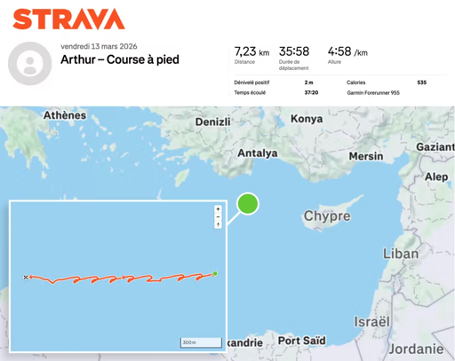
Why is it zig zagging?
He’s running up and down the deck